February, 2012
I climbed Kili along the Machame route. It is a technically more challenging route than some of the others, but you are exposed to more varied scenery and climate zones. The climb begins at Machame gate.

You spend most of the day on a steady uphill hike through the rainforest.

And camp in the middle of it, at Machame Camp.

The next day, very close by, is your first major marker, Machame Hut, at 3000m.

And on you go, hiking into the clouds.

And the environment becomes more and more eerie…


And you run into odd looking flowering plants like this one, which are the only ones that can grow at such high altitude. Check out the blue petals in between the green leaves. Unfortunately, I’ve completely forgotten it’s name…

Above a certain point, the vegetation becomes markedly shorter and less dense.

And eventually you arrive to the second camp, informally called Shira 2. It doesn’t have its own marker, instead pointing the way towards nearby Shira Hut and Shira Cave.

So naturally, you have to take a side trip to see Shira Cave, where people used to camp on this route, and set up fires inside, once upon a time. Here I am in it with my new favourite British couple, Jodie and Glen.

A view of Shira 2 camp on the way back from the cave, complete with helipad for those less adventurous types who wish to avoid hiking from the bottom. No, I’m not making that up.

And you get to wake up the next morning to this. Not a bad view to enjoy a cup of tea with…

The frost on the tent.

The next day consisted of climbing up to what’s known as the lava tower, at 4600m, to help acclimatize to the high altitude, and then back down to Barranco camp. it was long and hard, made harder because I picked up a stomach bug the night before, and was feverish and dehydrated from everything. I lost about 10lbs over the next couple of days. It was…tough.
Hitting 4000m

My guide, Wilson. An awesome, salt of the earth guy.

Glen, Jodie and I at the Lava Tower marker

The view from the Lava tower, where we stopped for lunch. My eyes are pretty sunken from the bug…

Exhausted, finally made it to Barranco camp. I couldn’t wait to throw off my clothes (well, most of them, because it was still pretty damn cold), and pass out in my sleeping bag.

The morning view from Barranco camp

And then we head through the alpine desert. Some of it is the result of the receding glacier. 10 years ago, parts of what we walked through would have been covered in ice.


The next camp is Karanga, but to get to it you have to head down through the Karanga Valley, and back up again.

At the base of Karanga valley is a glacial stream. It’s the last source of water for the next 2 camps – Karanga, which is up the other side, and Barafu, which is 3-4 hours away.


The vapour from my breath inside the tent.

The view toward Moshi from Karanga

The view towards Stella Point.

The hike up to Barafu is through seemingly endless Alpine desert. Barren but beautiful.


Finally reaching Barafu camp at 4600m, and situated a few metres away from a virtual vertical drop several hundred feet down. Going to the outhouse at night, situated right on the edge, one has to tread carefully…

After a few hours of shuteye, we woke at midnight to begin the trek up to Uhuru peak. Most take around 6 hours to make it to Stella Point, where they wait to see the sunrise. I told Wilson I wanted to make it to Uhuru for sunrise. From Stella to Uhuru is about 45m – 1hr, so it meant going at a considerably faster pace. This is harder than it sounds, as the -20C weather and 11% Oxygen combined with the increasingly steep and slippery inclines, mean any quickening of pace is felt immediately. The closer you get to Stella, the harder it becomes. And just to top it off, eventually your water freezes, even in an insulated reservoir. From Stella to Uhuru is a gentler climb, but the last 200m to Stella are brutal. All, however, is forgotten once you see the (now green) sign in the distance. Tanzania changed the sign from the classic wooden one to the new green one 3 months before I climbed, in celebration of 50 years of independence from British rule.
Euphoria – though it could have been the lack of oxygen… 🙂

The glacier at sunrise

Scenes from the way down. There are more than on the way up because a) when you’re cold and tired the last thing you care about is taking a photo, and b) the way down was, due to the scree, almost as hard as the way up, so Wilson and I stopped to rest a lot.


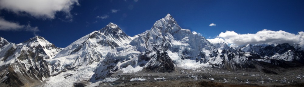
We camped one more night after a few hours of descent on the Marangu route, which is the route everyone takes to come down. I don’t actually have a lot of pictures from the camp, but this pic of Kili is worth sharing. It was the first time the weather was clear enough to see it, and I managed to find enough of a clearing in the forest to snap this one.

Signing out.

An illustrated map with the different types of vegetation/climate zones travelled through.

